

Multi-Modal Routing
Route every shipment by road, sea, air, or rail, with a truck-grade routing engine built into the platform.
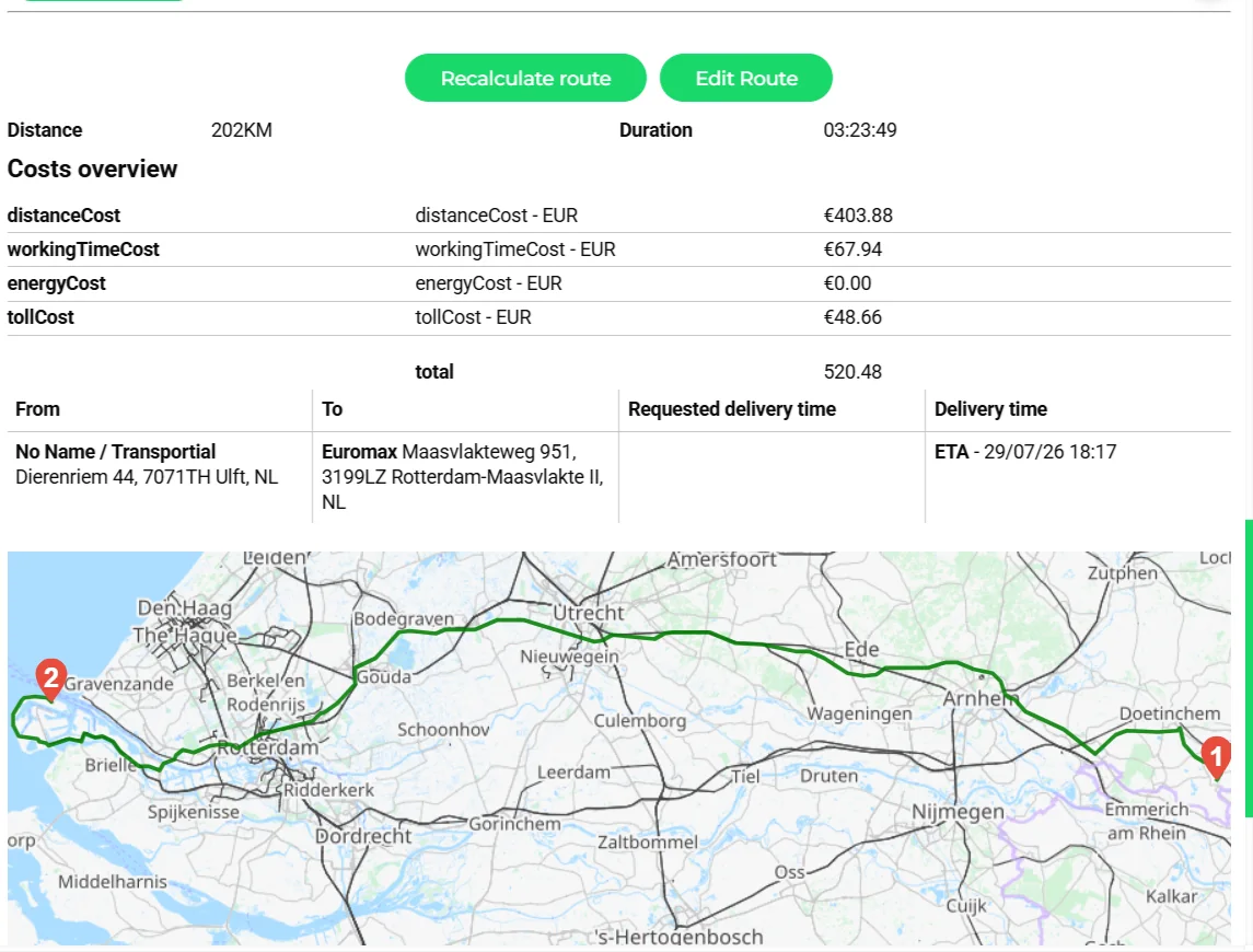
- Distance and duration for the whole route
- Cost overview: distance, working time, energy and toll
- Requested delivery time next to the calculated ETA
- Truck-attribute route on the map with numbered stops
Routing in logistics is never just "find the shortest path". Transportial's routing engine accounts for truck dimensions, hazmat restrictions, ferry crossings, maritime lanes, and air freight bookings, so the route you generate is the one your vehicle can actually travel.
What it does
Everything this module does, named the way you will find it in the product.
Road routing for trucks, not cars
- Pluggable route calculators
PTV xRoute, PTV Developer, HERE Routing v8, Google Directions and Routes, OSRM, or the self-hosted GraphHopper 7 with custom truck models. The engine is a platform setting; alternatives mode can compare engines side by side.
- Vehicle attributes on the route
Weights, axle loads and dimensions are derived from the assigned vehicle and passed to the engine, with an axle editor in the advanced options, so bridges, tunnels and weight limits are respected.
- Route alternatives
Fastest, eco, cheapest, toll route, toll-free route and up to three alternatives, compared in one table with distance, time, toll and CO₂e.
- Map overlays
Traffic incidents, traffic patterns, truck restrictions, toll roads, low-emission zones and places, on transport or satellite base layers, with an optional PTV vector map.
Costs, tolls and emissions on every route
- Cost mode
Calculate all costs, toll only or none per platform. Toll costs, including per-country parts, post to a dedicated pricing category so they reach the quote and the invoice.
- Working time and energy
Distance, working-time and energy costs come from the vehicle and driver cost pricing, so a route is priced as your operation prices it.
- CO₂e well-to-wheel and tank-to-wheel
Emission factors by fuel type and Euro class, well-to-wheel multipliers, and ISO 14083, GLEC or DIN EN 16258 reporting standards, with PTV Developer able to return ISO 14083:2023 figures.
- Recalculation policy
Recalculate always, only on change or manually; quote routes can be calculated with straight-line or circuity fallbacks when addresses are incomplete.
Sea, inland waterway, rail and air
- Maritime on MARNET
Sea routes are computed on the MARNET maritime network with twelve passages that can be opened or closed per platform: Suez, Panama, Malacca, Gibraltar, Dover, Bering, Magellan, Bab-el-Mandeb, Kiel, Corinth, Northwest and Northeast Passage.
- Inland waterway
A barge graph from OpenStreetMap with CEMT class, under-keel clearance, bridge clearance, draft and air draft constraints, and live water levels from Rijkswaterstaat (NL) and PEGELONLINE (DE).
- Rail
A rail graph from OpenStreetMap with a direct-line fallback, plus platform settings for gauge, axle load and UIC loading gauge.
- Air
Great-circle routing with a configurable cruise speed for air legs inside a multimodal order.
ETA you can promise
- ETA settings
Arrival radius, circuity factor, blending of live telematics speed and historical dwell times per location shape the ETA chain.
- Driver rest inside the ETA
The optional EU 561/2006 planner inserts breaks and daily rests into the chain, so an overnight delivery is not promised for a driver who must rest.
- Energy stops
Automatic energy (fuel or charging) stop planning with a safety margin and preferred providers, off by default.
- Parking and services
Secured truck parking and en-route services are booked through TRAVIS and appear as service bookings on the trip.
How it works
Start from locations or a vehicle
Pick stops in the Route planner, or select a vehicle to prefill its dimensions, weights and axle configuration.
Compare alternatives
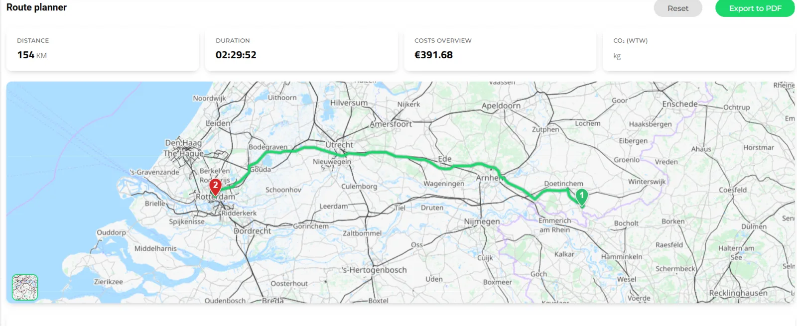
Fastest, eco, cheapest, toll and toll-free routes appear side by side with distance, time, toll, other costs and CO₂e tank-to-wheel and well-to-wheel.
Read the breakdown
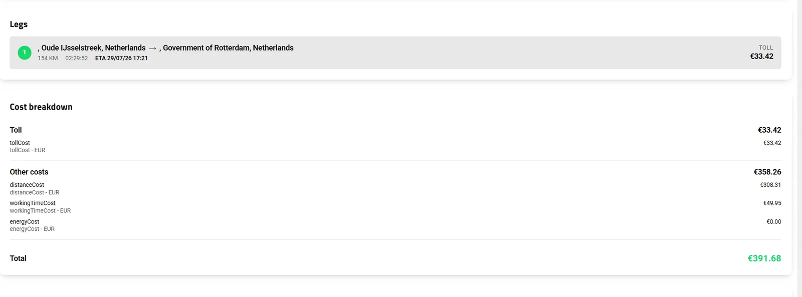
Legs list miles, duration and ETA per stop; the cost breakdown shows toll, distance, working time and energy.
Export or apply
Export the route to PDF for a customer or a driver, or apply it to a trip. Trips recalculate on change or on demand, according to the platform policy.
Why routing engines are a platform setting
Routing quality, license cost and coverage differ by engine and by country. A Dutch domestic carrier is well served by the self-hosted GraphHopper; a pan-European operation with strict truck attributes and toll accuracy usually wants PTV. Transportial makes the calculator a setting, keeps the vehicle attributes and cost model the same, and can run two engines side by side so the choice is measured, not guessed.
Heavy routing runs asynchronously. When the optimizer or a bulk import needs hundreds of routes, the work is queued to worker nodes over Kafka instead of blocking the planner's screen.
Multimodal means more than a road engine with a ferry
A container from Rotterdam to Basel may travel by barge, rail and truck. Each mode has its own graph and its own constraints: CEMT class and water levels on the Rhine, gauge and loading gauge on rail, height and axle load on the last road leg. Transportial routes each leg on the right graph and joins them under one order, so the ETA and the emissions add up per leg.
On sea legs the passage settings matter as much as the network: closing Suez or Bab-el-Mandeb for a platform reroutes every affected sea leg around the Cape, which is exactly what operators needed during the Red Sea disruptions.
Concepts & terminology
The words this module uses, with links to the full glossary where a term has its own page.
- Route calculator
- The engine that turns an ordered list of stops into a road route: PTV, PTV Developer, HERE, Google, OSRM or self-hosted GraphHopper.
- Truck attributes
- The vehicle's weight, axle loads, dimensions and hazmat class passed to the engine so the route avoids roads the truck cannot legally use.
- ETA / ETDGlossary
- Estimated time of arrival and departure per stop, built from the route, dwell times, telematics speed and optional driver rests.
- Well-to-wheel (WTW)
- Emissions including fuel production and distribution; tank-to-wheel (TTW) counts combustion only. Both are stored on every trip.
- MARNET
- The global maritime route network used for sea legs, with configurable passages.
- CEMT classGlossary
- The European classification of inland waterways by the vessel size they admit; used as a constraint on barge routing.
- Multimodal transportGlossary
- One shipment carried by two or more modes under one order, each leg routed on its own network.
- Circuity factor
- The ratio between road distance and straight-line distance, used to estimate distance when a full route is not yet calculated.
Works with
Connectors that feed or consume this module out of the box.
 PTV xRoute/xTour
Built for
Where this module carries the most weight, plus the free tools on the same topic.
The routing engine runs as a dedicated backend mode. Road routing uses GraphHopper's OpenStreetMap-based graph. Maritime routing uses the MARNET dataset. PTV calls are made via its REST API.
Frequently asked questions
Which routing engines can I use?
PTV xRoute (xServer), PTV Developer, HERE, Google Maps, OSRM and Transportial's self-hosted GraphHopper with truck models. You can also compare engines side by side and choose per route.
Are tolls calculated?
Yes. Toll costs, including per-country parts, are returned by the engine and posted to a toll pricing category so they can be quoted and invoiced. You can also compare toll and toll-free alternatives.
How are emissions calculated?
From built-in factors per fuel type and Euro class with well-to-wheel multipliers, or from PTV Developer's ISO 14083:2023 figures. Platforms choose the reporting standard (ISO 14083, GLEC, DIN EN 16258) and basis (WTW or TTW).
Does it route barges and trains?
Yes. Inland waterways use a barge graph with CEMT class, clearances and live water levels from RWS and PEGELONLINE; rail uses its own graph with gauge and loading-gauge settings.
Can I avoid the Suez Canal?
Yes. Twelve sea passages can be toggled per platform, and affected sea legs reroute automatically.
Do ETAs account for driver rest?
When the EU 561/2006 planner is enabled, breaks and daily rests are inserted into routes and ETA chains, so promised times already include the driver's mandatory rest.
View all features
Ready to put this to work?
Start free with full platform access, or talk to our team about your specific operation.